 титульная страница > Технологическая периферия > Garmin расширяет Outdoor Maps+ более чем полдюжиной новых функций
Garmin расширяет Outdoor Maps+ более чем полдюжиной новых функций

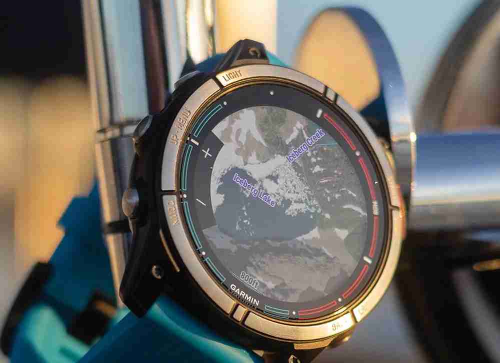
Garmin объявила о расширении функции Outdoor Maps, которую компания продолжает называть «премиальным картографическим решением». Для справки: хотя Outdoor Maps доступна по всему миру, некоторые новые функции доступны исключительно для клиентов в США. В частности, Garmin выделяет полдюжины эксклюзивных для США функций:
- Здания: определите свое местоположение или получите помощь в планировании маршрута с помощью слоя карты, показывающего двухмерные контуры зданий. Расширено и теперь включает все территории США, Канады, Мексики, Центральной Америки и Карибского бассейна.
- Кемпинги: найдите место, где можно переночевать, и узнайте, какие удобства предоставляются в США и Канаде.
- Точки DeLorme Atlas & Gazetteer: найдите достопримечательности США, такие как уникальные природные объекты, такие как горы и водопады, доступные развлекательные мероприятия на свежем воздухе, семейный отдых. достопримечательности, зоны отдыха, такие как государственные/национальные парки/леса, а также места для рыбалки или охоты.
- Точки наследия: смотрите замки, форты, маяки, религиозные объекты и другие исторические достопримечательности по всему миру, наложенные на карту. .
- Покрытие голосовой связи LTE: проверьте, доступно ли покрытие голосовой связи, с помощью слоя карты, показывающего покрытие LTE для Verizon, AT&T, UScell и T-Mobile Wireless. перевозчики по всей территории США.
- Баллы USFS: просмотрите места расположения палаток Лесной службы США для кемпинга, пеших прогулок, пикников, обучения на свежем воздухе, наблюдения за природой, рыбалки и многого другого.
По какой-то причине Garmin предлагает только две новые функции для клиентов Outdoor Maps, живущих в Европе. К сожалению, компания описывает это как расширение функциональности, которая уже была доступна в США. В этом случае Garmin теперь предоставляет европейским клиентам доступ к расширенной штриховке рельефа, которая отображает изменения высоты и особенности местности с помощью цветовых градиентов.
Кроме того, Garmin расширила растровые карты, которые принимают данные от поставщиков из Франции и Швейцарии для покажите, среди прочего, места для кемпинга, достопримечательности, источники воды, тропы и начала троп. Стоит иметь в виду, что Outdoor Maps остается годовой подпиской за 49,99 долларов США; Для получения дополнительной информации посетите веб-сайт Garmin.
Купите Garmin Edge 1050 на Amazon

-
 iOS 18.3 Особенности: все новое в iOS 18.3ios 18.3 является третьим основным обновлением операционной системы iOS 18, и, хотя она не такая функция, богатая, как ios 18.1 или ios 18.2, есть не...Технологическая периферия Опубликовано в 2025-03-23
 -
 Intel Core Ultra 7 258V Beats Amd Ryzen Z1 Extreme в игровом этажеintel Lunar Lake Line Offices xe2 LPG IGPU, и компания говорит, что ARC 140V, которая находится в некоторых из более высоких процессов, является «...Технологическая периферия Опубликовано в 2025-03-22
 -
 Протешенные характеристики и рендеры Infinix Zero Flip показывают поразительное сходство с последним перевернутым телефоном Tecno] Infinix, как ожидается, скоро объявит о своем первом складном смартфоне, и в преддверии его запуска, рендеринг и спецификации телефона, называемы...Технологическая периферия Опубликовано в 2025-02-25
 -
 Все, что вам нужно знать о интеллекте AppleApple Intelligence - это то, что Apple называет своим набором функций искусственного интеллекта, предварительно просмотрено на WWDC в июне 2024 года....Технологическая периферия Опубликовано в 2025-02-23
 -
 Lenovo раскрывает новый вариант цвета для игрового планшета Legion Y700 2024Lenovo готовится запустить Legion 2024 Y700 29 сентября в Китае. Этот новый планшет Android Gaming будет идти против Redmagic Nova, и компания уже...Технологическая периферия Опубликовано в 2025-02-07
 -
 INZONE M9 II: Sony выпускает новый игровой монитор, «идеально подходящий для PS5» с разрешением 4K и пиковой яркостью 750 нитINZONE M9 II является прямым преемником INZONE M9, которому сейчас чуть больше двух лет. Кстати, Sony сегодня также представила INZONE M10S, о котором...Технологическая периферия Опубликовано 21 декабря 2024 г.
 -
 Acer подтверждает дату анонса своих ноутбуков Intel Lunar LakeВ прошлом месяце Intel подтвердила, что выпустит новые чипы серии Core Ultra 200 3 сентября. Acer объявила, что проведет мероприятие Next@Acer 4 сентя...Технологическая периферия Опубликовано 21 декабря 2024 г.
 -
 AMD Ryzen 7 9800X3D выйдет в октябре; Ryzen 9 9950X3D и Ryzen 9 9900X3D дебютируют в следующем годуВ прошлом году AMD выпустила Ryzen 9 7950X3D и Ryzen 9 7900X3D перед Ryzen 7 7800X3D, который вышел пару недель спустя. С тех пор мы видели множество ...Технологическая периферия Опубликовано 10 декабря 2024 г.
 -
 Steam раздает очень популярную инди-игру, но только сегодняPress Any Button — инди-аркадная игра, разработанная индивидуальным разработчиком Евгением Зубко и выпущенная в 2021 году. Сюжет разворачивается вокру...Технологическая периферия Опубликовано 26 ноября 2024 г.
 -
 Сообщается, что превью Assassin’s Creed Shadows отменены, поскольку Ubisoft отказывается от участия в Tokyo Game Show 2024Ранее сегодня Ubisoft отменила свое онлайн-выступление на Tokyo Game Show из-за «различных обстоятельств». Это объявление было подтверждено официальны...Технологическая периферия Опубликовано 25 ноября 2024 г.
 -
 Цена на игру Sony семилетней давности внезапно выросла вдвоеБазовая цена PlayStation 5 Pro составляет 700 долларов США, а стоимость полного пакета, включая привод и подставку, достигает 850 долларов США. Хотя S...Технологическая периферия Опубликовано 22 ноября 2024 г.
 -
 Сделка | Чудовищный игровой ноутбук MSI Raider GE78 HX с RTX 4080, Core i9 и 32 ГБ памяти DDR5 поступил в продажуДля геймеров, которые в основном используют игровой ноутбук в качестве замены настольного компьютера, лучшим выбором может стать большой ноутбук, тако...Технологическая периферия Опубликовано 20 ноября 2024 г.
 -
 Teenage Engineering представляет необычный EP-1320 Medieval как первый в мире средневековый «инструментальный электронный инструмент»То, что Teenage Engineering – это компания, которая идет в такт совсем другому барабанщику, ни для кого не секрет – на самом деле именно это привлекае...Технологическая периферия Опубликовано 19 ноября 2024 г.
 -
 Google Photos получает пресеты на базе искусственного интеллекта и новые инструменты редактированияФункции редактирования видео, присутствующие в Google Фото, только что получили поддержку функций искусственного интеллекта, и эти изменения улучшат п...Технологическая периферия Опубликовано 19 ноября 2024 г.
 -
 Выпущен Tecno Pop 9 5G с внешним видом в стиле iPhone 16 и бюджетными характеристикамиTecno подтвердила, что откажется от геометрического внешнего вида Pop 8 в пользу приподнятого выступа камеры, якобы вдохновленного новым Phone 16 и ег...Технологическая периферия Опубликовано 19 ноября 2024 г.
Изучайте китайский
- 1 Как сказать «гулять» по-китайски? 走路 Китайское произношение, 走路 Изучение китайского языка
- 2 Как сказать «Сесть на самолет» по-китайски? 坐飞机 Китайское произношение, 坐飞机 Изучение китайского языка
- 3 Как сказать «сесть на поезд» по-китайски? 坐火车 Китайское произношение, 坐火车 Изучение китайского языка
- 4 Как сказать «поехать на автобусе» по-китайски? 坐车 Китайское произношение, 坐车 Изучение китайского языка
- 5 Как сказать «Ездить» по-китайски? 开车 Китайское произношение, 开车 Изучение китайского языка
- 6 Как будет плавание по-китайски? 游泳 Китайское произношение, 游泳 Изучение китайского языка
- 7 Как сказать «кататься на велосипеде» по-китайски? 骑自行车 Китайское произношение, 骑自行车 Изучение китайского языка
- 8 Как поздороваться по-китайски? 你好Китайское произношение, 你好Изучение китайского языка
- 9 Как сказать спасибо по-китайски? 谢谢Китайское произношение, 谢谢Изучение китайского языка
- 10 How to say goodbye in Chinese? 再见Chinese pronunciation, 再见Chinese learning


