Process multiband rasters (Sentinel-with hndex and create indices
Hi, In previous blog we talked about how we can do raster analysis using h3 indexes and postgresql for a single band raster. In this blog we will talk about how we can process multiband raster and create indices with ease. We will be using sentinel-2 image and create NDVI from the processed h3 cells and visualize the results
Download sentinel 2 data
We are downloading the sentinel 2 data from https://apps.sentinel-hub.com/eo-browser/ in Pokhara, Nepal Area , Just to make sure lake is in the image grid so that it would be easy for us to validate the NDVI result
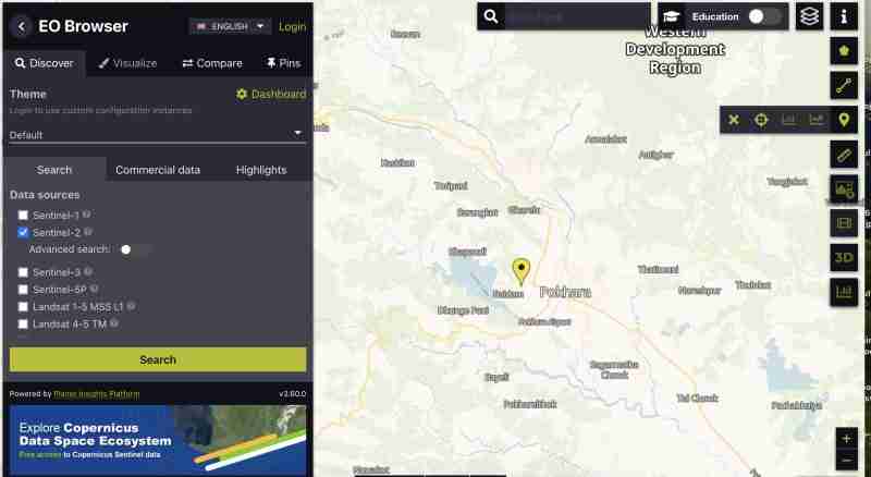
To download sentinel image with all bands :
- You need to create an account
- Find the image in your area select the grid that covers your Area of interest
- Zoom to the grid, And click on
 icon on right vertical bar
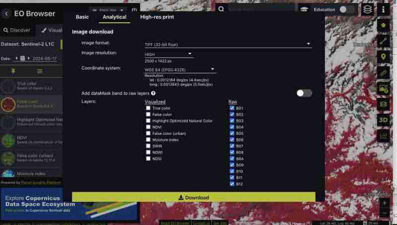
 - After that go to analytical tab and select all the bands with image format as tiff 32 bit , high resolution , wgs1984 format and all bands checkd
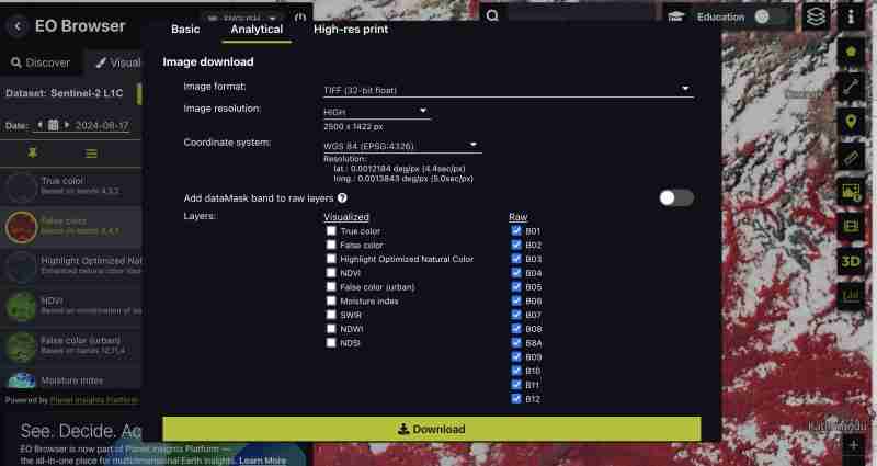
You can also download pregenerated indices such as NDVI , False color tiff only or specific bands whichever best suits your need . We are downloading all the bands as we wanna do the processing by ourselves
- Click download
Preprocess
We get all the bands as separate tiff from the sentinel as we downloaded raw format
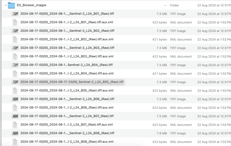
- lets create a composite image :
This can be done through GIS tools or gdal
- Using gdal_merge:
We need to rename the downloaded file to band1,band2 like this to avoid slashes in the filename
Lets process upto band 9 for this exercise , you can choose the band as your requirement
gdal_merge.py -separate -o sentinel2_composite.tif band1.tif band2.tif band3.tif band4.tif band5.tif band6.tif band7.tif band8.tif band9.tif
- Using QGIS :
- Load all individual bands to QGIS
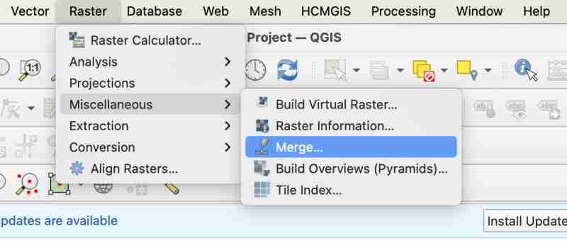
- Go to Raster > Miscellanaeous > Merge
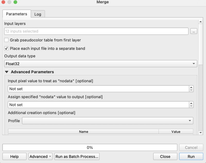
- While merging you need to make sure you check 'place each input file in sep band'
- Now export your merged tiff to raw geotiff as composite
Housekeeping
- Make sure your image is in WGS1984 in our case image is already is in ws1984 so no need for the conversion
- Make sure you don't have any nodata if yes fill them with 0
gdalwarp -overwrite -dstnodata 0 "$input_file" "${output_file}_nodata.tif"
- Finally make sure your ouput image is in COG
gdal_translate -of COG "$input_file" "$output_file"
I am using the bash script provided in cog2h3 repo to automate those
sudo bash pre.sh sentinel2_composite.tif
Process and creation of h3 cells
Now finally as we have done the preprocessing script , lets move forward to compute h3 cells for each bands in the composite cog image
- Install cog2h3
pip install cog2h3
- Export you database credentials
export DATABASE_URL="postgresql://user:password@host:port/database"
- Run
We are using resolution 10 for this sentinel image, however you will also see in the script itself which will print the optimal resolution for your raster that makes the h3 cell smaller than your smallest of pixel in raster.
cog2h3 --cog sentinel2_composite_preprocessed.tif --table sentinel --multiband --res 10
It took a minute for us to compute and store result in postgresql
Logs :
2024-08-24 08:39:43,233 - INFO - Starting processing
2024-08-24 08:39:43,234 - INFO - COG file already exists at sentinel2_composite_preprocessed.tif
2024-08-24 08:39:43,234 - INFO - Processing raster file: sentinel2_composite_preprocessed.tif
2024-08-24 08:39:43,864 - INFO - Determined Min fitting H3 resolution for band 1: 11
2024-08-24 08:39:43,865 - INFO - Resampling original raster to: 200.786148m
2024-08-24 08:39:44,037 - INFO - Resampling Done for band 1
2024-08-24 08:39:44,037 - INFO - New Native H3 resolution for band 1: 10
2024-08-24 08:39:44,738 - INFO - Calculation done for res:10 band:1
2024-08-24 08:39:44,749 - INFO - Determined Min fitting H3 resolution for band 2: 11
2024-08-24 08:39:44,749 - INFO - Resampling original raster to: 200.786148m
2024-08-24 08:39:44,757 - INFO - Resampling Done for band 2
2024-08-24 08:39:44,757 - INFO - New Native H3 resolution for band 2: 10
2024-08-24 08:39:45,359 - INFO - Calculation done for res:10 band:2
2024-08-24 08:39:45,366 - INFO - Determined Min fitting H3 resolution for band 3: 11
2024-08-24 08:39:45,366 - INFO - Resampling original raster to: 200.786148m
2024-08-24 08:39:45,374 - INFO - Resampling Done for band 3
2024-08-24 08:39:45,374 - INFO - New Native H3 resolution for band 3: 10
2024-08-24 08:39:45,986 - INFO - Calculation done for res:10 band:3
2024-08-24 08:39:45,994 - INFO - Determined Min fitting H3 resolution for band 4: 11
2024-08-24 08:39:45,994 - INFO - Resampling original raster to: 200.786148m
2024-08-24 08:39:46,003 - INFO - Resampling Done for band 4
2024-08-24 08:39:46,003 - INFO - New Native H3 resolution for band 4: 10
2024-08-24 08:39:46,605 - INFO - Calculation done for res:10 band:4
2024-08-24 08:39:46,612 - INFO - Determined Min fitting H3 resolution for band 5: 11
2024-08-24 08:39:46,612 - INFO - Resampling original raster to: 200.786148m
2024-08-24 08:39:46,619 - INFO - Resampling Done for band 5
2024-08-24 08:39:46,619 - INFO - New Native H3 resolution for band 5: 10
2024-08-24 08:39:47,223 - INFO - Calculation done for res:10 band:5
2024-08-24 08:39:47,230 - INFO - Determined Min fitting H3 resolution for band 6: 11
2024-08-24 08:39:47,230 - INFO - Resampling original raster to: 200.786148m
2024-08-24 08:39:47,239 - INFO - Resampling Done for band 6
2024-08-24 08:39:47,239 - INFO - New Native H3 resolution for band 6: 10
2024-08-24 08:39:47,829 - INFO - Calculation done for res:10 band:6
2024-08-24 08:39:47,837 - INFO - Determined Min fitting H3 resolution for band 7: 11
2024-08-24 08:39:47,837 - INFO - Resampling original raster to: 200.786148m
2024-08-24 08:39:47,845 - INFO - Resampling Done for band 7
2024-08-24 08:39:47,845 - INFO - New Native H3 resolution for band 7: 10
2024-08-24 08:39:48,445 - INFO - Calculation done for res:10 band:7
2024-08-24 08:39:48,453 - INFO - Determined Min fitting H3 resolution for band 8: 11
2024-08-24 08:39:48,453 - INFO - Resampling original raster to: 200.786148m
2024-08-24 08:39:48,461 - INFO - Resampling Done for band 8
2024-08-24 08:39:48,461 - INFO - New Native H3 resolution for band 8: 10
2024-08-24 08:39:49,046 - INFO - Calculation done for res:10 band:8
2024-08-24 08:39:49,054 - INFO - Determined Min fitting H3 resolution for band 9: 11
2024-08-24 08:39:49,054 - INFO - Resampling original raster to: 200.786148m
2024-08-24 08:39:49,062 - INFO - Resampling Done for band 9
2024-08-24 08:39:49,063 - INFO - New Native H3 resolution for band 9: 10
2024-08-24 08:39:49,647 - INFO - Calculation done for res:10 band:9
2024-08-24 08:39:51,435 - INFO - Converting H3 indices to hex strings
2024-08-24 08:39:51,906 - INFO - Overall raster calculation done in 8 seconds
2024-08-24 08:39:51,906 - INFO - Creating or replacing table sentinel in database
2024-08-24 08:40:03,153 - INFO - Table sentinel created or updated successfully in 11.25 seconds.
2024-08-24 08:40:03,360 - INFO - Processing completed
Analyze
Since now we have our data in postgresql , Lets do some analysis
- Verify we have all the bands we processed ( Remember we processed from band 1 to 9 )
select *
from sentinel

- Compute ndvi for each cell
explain analyze
select h3_ix , (band8-band4)/(band8 band4) as ndvi
from public.sentinel
Query Plan :
QUERY PLAN                                                                                                       |
-----------------------------------------------------------------------------------------------------------------
Seq Scan on sentinel  (cost=0.00..28475.41 rows=923509 width=16) (actual time=0.014..155.049 rows=923509 loops=1)|
Planning Time: 0.080 ms                                                                                          |
Execution Time: 183.764 ms                                                                                       |
As you can see here for all the rows in that area the calculation is instant . This is true for all other indices and you can compute complex indices join with other tables using the h3_ix primary key and derive meaningful result out of it without worrying as postgresql is capable of handling complex queries and table join.
Visualize and verification
Lets visualize and verify if the computed indices are true
- Create table ( for visualizing in QGIS )
create table ndvi_sentinel
as(
select h3_ix , (band8-band4)/(band8 band4) as ndvi
from public.sentinel )
- Lets add geometry to visualize the h3 cells This is only necessary to visualize in QGIS , if you build an minimal API by yourself you don't need this as you can construct geometry directly from query
ALTER TABLE ndvi_sentinel
ADD COLUMN geometry geometry(Polygon, 4326)
GENERATED ALWAYS AS (h3_cell_to_boundary_geometry(h3_ix)) STORED;
- Create index on geometry
create index on ndvi_sentinel(geometry);
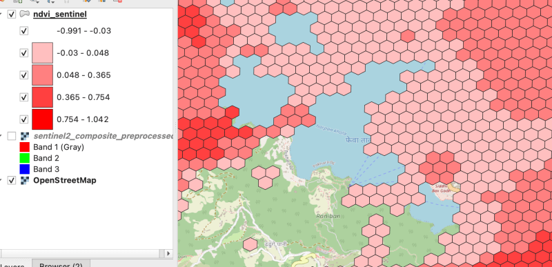
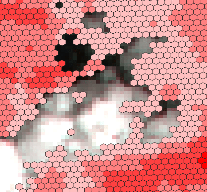
- Connect your database in QGIS and visualize the table on the basis of ndvi value Lets get the area near Fewa lake or cloud
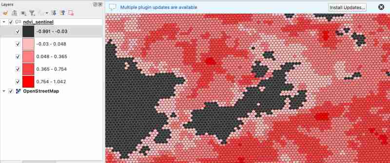
As we know value between -1.0 to 0.1 should represent Deep water or dense clouds
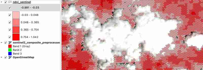
lets see if thats true ( making first category as transparent to see the underlying image )
- Check clouds :
- Check Lake
As there were clouds around the lake hence nearby fields are covered by cloud which makes sense
Thank you for reading ! See you in next blog
-
 How to Resolve \"Refused to Load Script...\" Errors Due to Android\'s Content Security Policy?Unveiling the Mystery: Content Security Policy Directive ErrorsEncountering the enigmatic error "Refused to load the script..." when deployi...Programming Posted on 2025-04-27
 -
 Python efficient way to remove HTML tags from textStripping HTML Tags in Python for a Pristine Textual RepresentationManipulating HTML responses often involves extracting relevant text content while e...Programming Posted on 2025-04-27
 -
 How to Combine Data from Three MySQL Tables into a New Table?mySQL: Creating a New Table from Data and Columns of Three TablesQuestion:How can I create a new table that combines selected data from three existing...Programming Posted on 2025-04-27
 -
 The difference between PHP and C++ function overload processingPHP Function Overloading: Unraveling the Enigma from a C PerspectiveAs a seasoned C developer venturing into the realm of PHP, you may encounter t...Programming Posted on 2025-04-27
 -
 Why Isn\'t My CSS Background Image Appearing?Troubleshoot: CSS Background Image Not AppearingYou've encountered an issue where your background image fails to load despite following tutorial i...Programming Posted on 2025-04-27
 -
 How to Parse JSON Arrays in Go Using the `json` Package?Parsing JSON Arrays in Go with the JSON PackageProblem: How can you parse a JSON string representing an array in Go using the json package?Code Exampl...Programming Posted on 2025-04-27
 -
 How to add axes and tags to PNG files in Java?How to Annotate a PNG File with Axes and Labels in JavaAdding axes and labels to an existing PNG image can be challenging. Rather than attempting modi...Programming Posted on 2025-04-27
 -
 Can You Use CSS to Color Console Output in Chrome and Firefox?Displaying Colors in JavaScript ConsoleIs it possible to use Chrome's console to display colored text, such as red for errors, orange for warnings...Programming Posted on 2025-04-27
 -
 Which Method for Declaring Multiple Variables in JavaScript is More Maintainable?Declaring Multiple Variables in JavaScript: Exploring Two MethodsIn JavaScript, developers often encounter the need to declare multiple variables. Two...Programming Posted on 2025-04-27
 -
 How to efficiently insert data into multiple MySQL tables in one transaction?MySQL Insert into Multiple TablesAttempting to insert data into multiple tables with a single MySQL query may yield unexpected results. While it may s...Programming Posted on 2025-04-27
 -
 Why Does Microsoft Visual C++ Fail to Correctly Implement Two-Phase Template Instantiation?The Mystery of "Broken" Two-Phase Template Instantiation in Microsoft Visual C Problem Statement:Users commonly express concerns that Micro...Programming Posted on 2025-04-27
 -
 Python metaclass working principle and class creation and customizationWhat are Metaclasses in Python?Metaclasses are responsible for creating class objects in Python. Just as classes create instances, metaclasses create ...Programming Posted on 2025-04-27
 -
 How Can I Efficiently Read a Large File in Reverse Order Using Python?Reading a File in Reverse Order in PythonIf you're working with a large file and need to read its contents from the last line to the first, Python...Programming Posted on 2025-04-27
 -
 How to deal with sliced memory in Go language garbage collection?Garbage Collection in Go Slices: A Detailed AnalysisIn Go, a slice is a dynamic array that references an underlying array. When working with slices, i...Programming Posted on 2025-04-27
 -
 Reasons why Python does not report errors to the slicing of the hyperscope substringSubstring Slicing with Index Out of Range: Duality and Empty SequencesIn Python, accessing elements of a sequence using the slicing operator, such as ...Programming Posted on 2025-04-27
Study Chinese
- 1 How do you say "walk" in Chinese? 走路 Chinese pronunciation, 走路 Chinese learning
- 2 How do you say "take a plane" in Chinese? 坐飞机 Chinese pronunciation, 坐飞机 Chinese learning
- 3 How do you say "take a train" in Chinese? 坐火车 Chinese pronunciation, 坐火车 Chinese learning
- 4 How do you say "take a bus" in Chinese? 坐车 Chinese pronunciation, 坐车 Chinese learning
- 5 How to say drive in Chinese? 开车 Chinese pronunciation, 开车 Chinese learning
- 6 How do you say swimming in Chinese? 游泳 Chinese pronunciation, 游泳 Chinese learning
- 7 How do you say ride a bicycle in Chinese? 骑自行车 Chinese pronunciation, 骑自行车 Chinese learning
- 8 How do you say hello in Chinese? 你好Chinese pronunciation, 你好Chinese learning
- 9 How do you say thank you in Chinese? 谢谢Chinese pronunciation, 谢谢Chinese learning
- 10 How to say goodbye in Chinese? 再见Chinese pronunciation, 再见Chinese learning


